
Bring your geospatial data and your teams together.
Birdi makes it easy for technical and non-technical teams to work from the same map. Upload, process, and share geospatial insights from one simple, centralized platform.
.png)
Trusted by top teams

.png)
.png)
.png)


A shared view of truth for your entire team
Birdi helps bridge the gap between GIS experts, operations teams, and decision-makers—so no one’s left guessing, and everyone stays aligned.
.png)
Collaboration that keeps everyone on the same page
Birdi’s collaboration tools bring clarity to your projects. Add comments directly on maps, track changes in the activity feed, and get notified with email updates. With role-based access and instant sharing links, teamwork has never been easier.

.png)
Geospatial tools that everyone can use
Whether you're deep in GIS or just need a clear view of your site, Birdi keeps things simple.
Our platform is packed with powerful tools—minus the complexity—so everyone can get what they need from the data, fast.
.png)

One map, all your stakeholders
Tired of data stuck in tools only your GIS team can access?
Birdi is built for cross-team collaboration, letting you bring in project managers, field staff, execs, and clients—no downloads or specialist training required.
Stop stitching together systems
Forget jumping between file shares, email threads, and legacy software.
With Birdi, your orthomosaics, digital elevation models, annotations, and reports all live in one place — easily accessible for your team, always up to date.
.png)
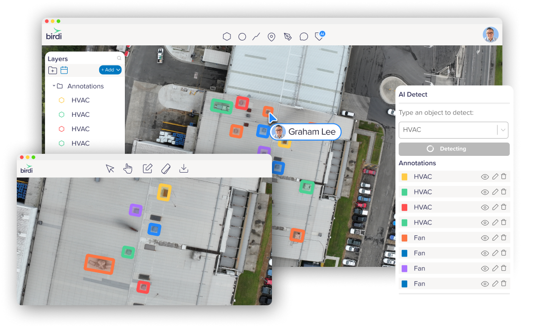
See results directly on the map
AI detections appear directly on your orthomosaic, so teams can spot patterns, densities, and hotspots straight away —without switching views or juggling files.
AI that understands spatial context
Birdi’s models consider spatial context within your imagery, making it easier to distinguish between similar or overlapping features — like vehicles and containers.
Flexible detection for different needs
Use Point Mode for quick counts (like trees or equipment), or Area Mode to capture footprints and areas such as stockpiles, roofs, or car parks, depending on the task at hand.
Share results without extra steps
All detections stay connected to your map, so AI results can be easily shared with teammates, clients, or contractors — no manual exports or re-uploads required.
Turn detections into usable insight
Each detection links automatically to measurements like count, area, or volume — helping teams move from visual data to clear, actionable insight in seconds.
One consistent workflow
Whether you’re assessing vegetation, assets, or site progress, the same intuitive tools adapt to different inspection types, keeping work simple and consistent.
Designed to complement your existing GIS stack
Already using complex GIS software or working across multiple systems? Birdi doesn’t replace your tools — it brings everything and everyone together.
Upload processed outputs like orthomosaics, elevation models, and contours from your existing workflows, or generate them in Birdi. Then visualize, annotate, and share maps easily with your wider team — no specialist tools or training needed.
Birdi is the collaboration layer that connects your geospatial work with the rest of your business.
.png)
From shared data to better decisions
Turn your geospatial data into clear insights and easy-to-share outputs — all in Birdi.
.png)
AI-powered media reports
Quickly surface key insights from your captured imagery. Birdi’s reports use intelligent tagging, notes, and AI tools to highlight issues and areas of interest, helping you make confident decisions without the manual effort.
Map canvas export
Export a snapshot of your active map view — including visible layers, legend, north arrow, and scale. Ideal for sharing site progress, giving stakeholders context, or producing visual summaries in PDF or PNG.
Annotation report
Export annotations and their attributes directly to CSV for deeper analysis or record keeping.
A unified workspace for everyone
Birdi is built for busy teams from the ground to the desk.
Upload anything
Bring in imagery, vectors, point clouds, 3D data, and more — Birdi can visualize it all.
Learn more

Collaboration tools
Collaborate live — see teammates on the map and leave comments or tags.
Learn more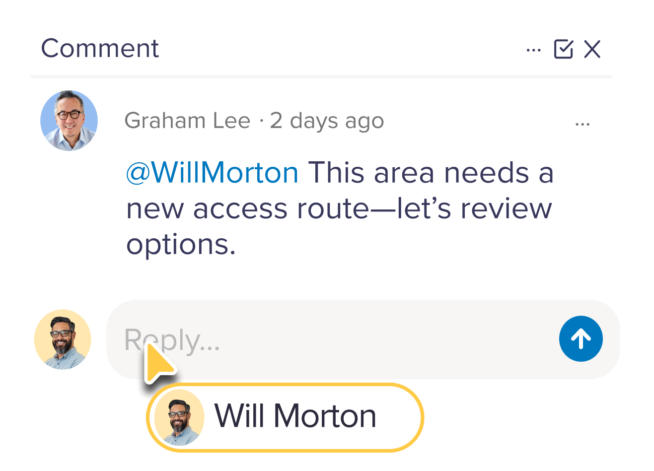
Data processing
Generate orthomosaics, DEMs, meshes, and more — fast, accurate, and all in one place.
Annotation tools
Draw, measure, and mark up maps with geo-referenced annotations ready for export.
Reports
Generate reports from your maps for inspections, insights and compliance.
Branding
Add your logo to workspaces to keep your maps looking on-brand.
Multiple workspaces
Organize sites, projects, or teams separately—all under one account.
Sharing
Share maps with teammates, stakeholders or guests in just a few clicks.
Geospatial success stories
Trusted by teams who rely on geospatial insight to make real-world decisions.


Senior Associate

Large educational provider

Senior Associate

Frequently asked questions

How does Birdi help teams work better with spatial data?
Birdi makes it easy for teams to access and work from the same up-to-date data, rather than relying on disconnected systems or static reports. Everyone—from field teams to office-based stakeholders—can view, analyze, and collaborate in one place, which helps reduce miscommunication and speeds up decision-making.
What kind of insights can I get from Birdi?
Teams use Birdi to understand things like stockpile volumes, terrain changes, site progress, and asset conditions. It helps turn raw imagery and survey data into something you can actually use to make decisions.
How is Birdi different from typical mapping or GIS software?
Traditional GIS and mapping tools are often built for advanced users, which can make them harder for broader teams to adopt. As a result, data often ends up sitting with a few specialists, spread across different systems, or shared as static outputs.
Birdi is designed as a shared workspace where your data is accessible, visual, and easy to work with. It brings teams onto the same page so everyone is working from the same source of truth, not disconnected files or outdated reports.
Do I need to replace my existing geospatial tools to use Birdi?
No. Birdi is designed to sit alongside your existing tools, not replace them. You can continue using your preferred capture, processing and GIS workflows, then bring that data into Birdi to make it easier to share, review, and turn into insights with your team.
How quickly can I start getting value from Birdi?
Most teams can upload data and start exploring it within minutes. From there, it’s about using tools like measurements, annotations, and comparisons to quickly extract insights and share them with stakeholders.
Can I easily share insights with my team or clients?
Yes. Birdi is built for collaboration, so you can share maps, measurements, and annotations with internal teams or external stakeholders without needing to export or rebuild reports.
Do I need GIS experience to use Birdi?
No. Birdi is designed so both technical and non-technical users can explore and understand spatial data, without needing deep GIS knowledge.
What types of teams typically use Birdi?
Operations teams, engineers, surveyors, and consultants use Birdi to monitor sites, track changes over time, and communicate insights clearly across projects.
How accurate are the insights from Birdi?
The accuracy depends on how the data is captured, but Birdi processes high-resolution data into reliable outputs that teams can confidently use for measurement, analysis, and reporting.
Bring your spatial data and your team into one place
Get started with Birdi
.png)
