
Powerful geospatial tools. One unified platform.
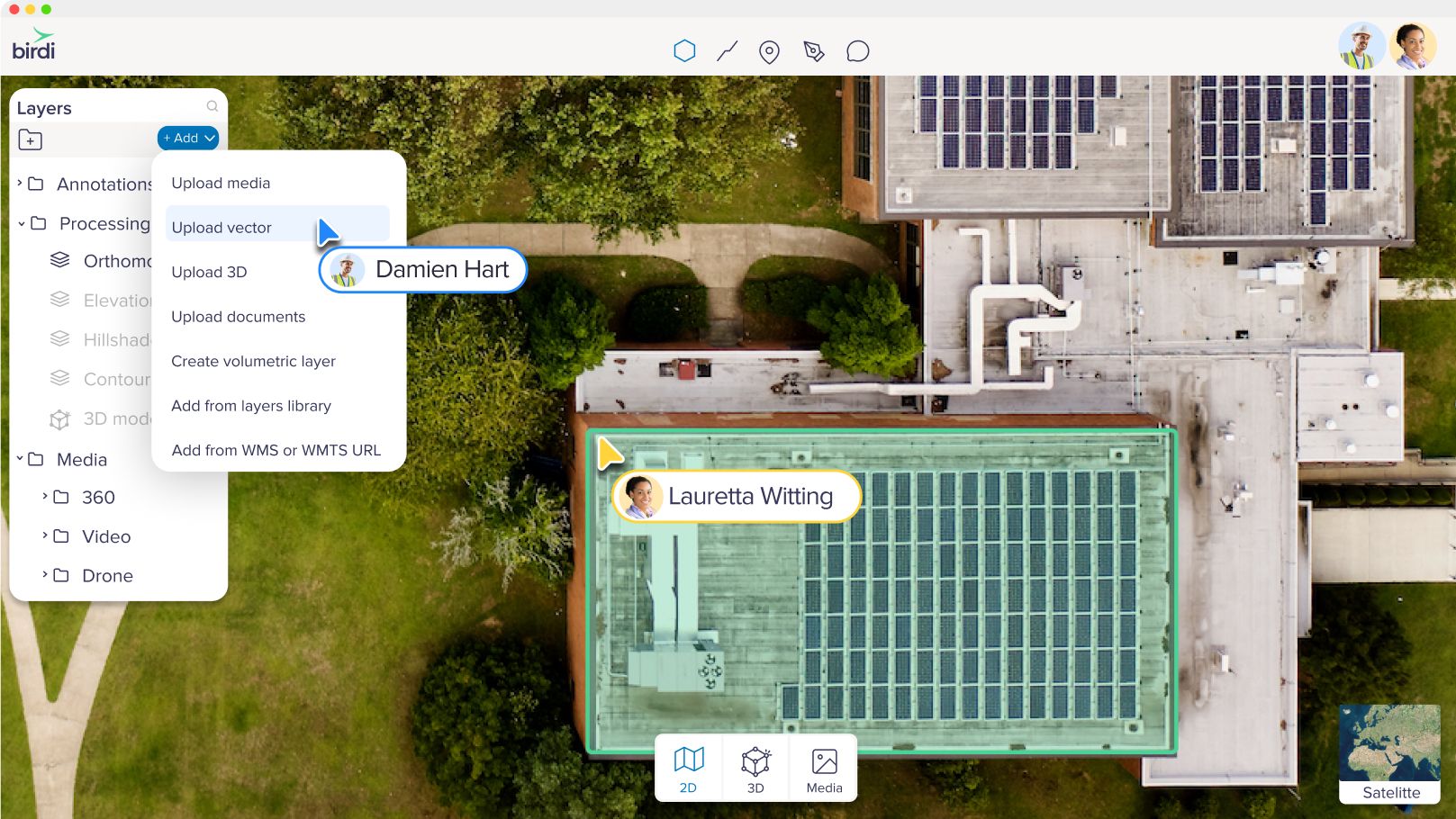
Upload, visualize and explore
Bring your spatial data together in one place. Upload orthomosaics, contours, point clouds, shapefiles and more—then explore it all using Birdi’s interactive 2D and 3D tools. Apply styling, toggle map layers, and compare changes over time with ease.
Media
Upload and preview all your ground or aerial imagery, 360s, and videos—organized, secure, and ready to work with.
Orthomosaic
View high-resolution, spatially accurate orthomosaics for precise mapping and decision-making.
Vector
Import and overlay shapefiles, DXFs, KMLs and more, to bring your data into geospatial context.
3D
Explore point clouds and textured 3D meshes in your browser—no special software required.
Basemaps
Customize your map with satellite, terrain, or street views to match your project needs.
Documents & reference files
Upload supporting files like non-georeferenced images, PDFs, and project documents to keep everything in one place.
Inspect, annotate and manage your spatial data.
Get from image to insight without switching tools. Birdi helps you identify what matters with easy-to-use markup, measurement, and inspection features. Whether you’re doing site assessments or asset reviews, everything stays organized and accessible in one place.


Smarter mapping with tags, tables, and tools
Add structure to your maps with tags, markers and measurements. Use the table view to search, filter and sort through your data.
Measurement tools
Measure distances, areas, and elevation directly on your map with precision and ease.
.png)
View-switching & filtering
Toggle between map layers and data types, and filter what you see to focus on what matters.
Table view
See your spatial data in a structured table: search, filter, and sort.
Tagging & labels
Add custom tags and labels to organize and highlight important features on your map.
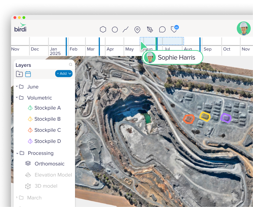
Volumetric
Calculate and export volumes from elevation models and point clouds quickly and accurately.
Layers toolbox
Control visibility, reorder layers, and customize how your data appears—all in one toolbox.
Styling
Style your raster and vector layers to highlight the insights that matter most.
Collaborate and share
Work better together—inside and outside your organization. Share maps, files, and data views with colleagues, contractors, and clients. Set the right access levels and keep everyone aligned, no matter where they’re working from. Leave comments directly on the map, so conversations stay connected to the work at hand.
Comment
Collaborate with your team by adding comments and annotations directly on the map.
Activity feed
Keep everyone in the loop with activity updates.
Share links
Share public view-only URLs to specific maps or files—no login needed, perfect for quick access.
Compare your data over time
Stay on top of your geospatial projects with a clear, chronological view of all activity. The timeline makes it simple to follow inspections, uploads, and updates as they happen — so your team can revisit past work, demonstrate compliance, and keep projects moving with confidence.
Timeline view
Step through your data over time with an interactive timeline that make changes easy to see.
Split screen
Compare two datasets side-by-side in split screen for faster insights.
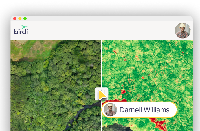
Difference grids
Highlight and measure variations instantly with difference grids.
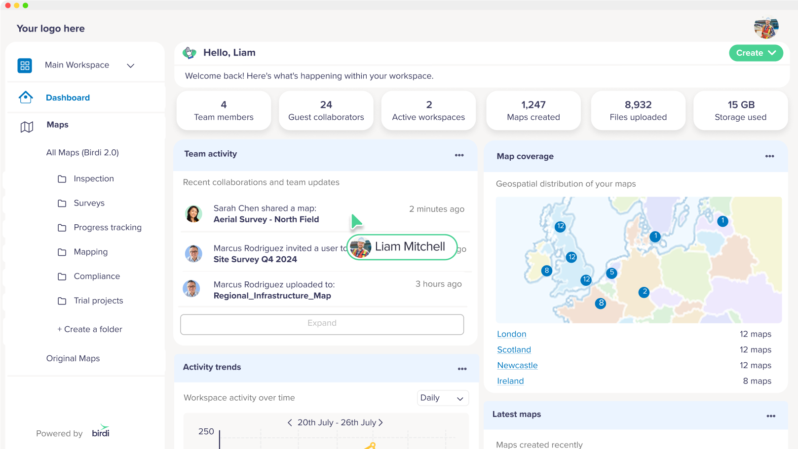
All-in-one workspace tools
The dashboard brings together everything happening across your workspace — recent uploads, processing progress, key outputs, and activity trends. Stay up to date on team comments and collaborations, so you’re always in the loop on both the work and the conversation that drives it.
Branding
Customize your workspace with your company’s logo for a consistent, professional experience.
Workspaces
Organize projects and data by client, site, or team—keeping everything in one place.
User roles & access
Control who sees what with flexible permission settings for viewers, editors, and admins.

Click to detect features
Select any object directly in your image with a single click, and Birdi will instantly detect and label all matching features.
Smart table summaries
Every detection is automatically listed in a table view, so you can review, filter, and export to CSV for further analysis or compliance records.
Type to detect features
Enter a simple text prompt—like “trees,” “machinery,” or “bolts”—and Birdi will automatically find and label every matching feature in your image.
Batch process multiple images
Run AI detection across an entire image set in one go, so you can process inspections at scale without opening each file individually.
Map view badges for quick checks
Detected features are flagged with badges on the geo-icon in map view, giving you instant situational awareness without opening each image.
No GIS experience needed
Designed for field teams, operators, and technical users alike.
Map processing
Birdi processes your aerial imagery into map-ready layers—no specialist skills required.
Map-ready 2D outputs
Generate high-resolution, georeferenced layers ready to inspect, measure, and share:
- Orthomosaics
- Digital Elevation Models (DEMs)
- Contours
- Hillshades
- And more

Immersive 3D outputs
Build detailed 3D models for site visualization, terrain analysis, and accurate measurements from every angle.

Custom outputs & processing
Need something outside the standard set? Birdi supports custom outputs to suit your project needs—from specific file formats to unique processing requirements.
Reporting & Insights
Turn raw data into real insights. Automatically calculate terrain volumes, generate elevation profiles, export to your GIS formats, and get the insights you need to make confident decisions.
PDF reports
Generate clean, shareable PDF reports with annotated visuals, measurements, and key site insights.

CSV exports
Export tabular data—such as volume calculations or inspection results—for easy analysis in spreadsheets or GIS tools.

Layer exports
Download georeferenced outputs like orthomosaics, contours, and vector files in standard GIS formats.

Certified reports
Access survey-grade reports produced by our certified survey partners for compliance, permitting, or legal documentation.

.png)
Custom reports
We can customize your reports to match internal templates, client requirements, or project-specific formats.

Advanced GIS tools
For advanced users, Birdi offers full control over spatial references and integrations with your GIS ecosystem.
External layer overlays
Bring in WMTS or WMS layers to compare against planning zones, cadastral data, or other reference layers.

Compatibility
Export files and layers in standard formats compatible with advanced GIS platforms like QGIS and ArcGIS.
Slope stability monitoring
Track changes over time using elevation models, contours, and terrain analysis tools.
GCP support
Incorporate Ground Control Points to increase the spatial accuracy of your outputs when required.
Custom coordinate systems
Work in your preferred projection—Birdi supports custom EPSG codes and local grid systems.
Data re-projection
Re-project data layers on export to match your GIS standards or regulatory requirements.