
How to Organize Repeat Drone Surveys of the Same Site

TL;DR: Organize repeat drone surveys by place, not by flight. Define each site once, with a boundary, and keep every survey of it together. Then carry the site's control and earlier elevation surfaces into the next survey, and give the whole team the same site to open, so the history is in one place.
Key takeaways
- Construction teams lose time looking for data. In one 2018 survey of nearly 600 construction leaders, people spent about 5.5 hours a week hunting for project information.
- Organize by place, because the questions are about places. "What changed at the quarry since last month?" needs every survey of the quarry together.
- Carry control and surfaces forward, so each new survey lines up with the last one.
- Keep capture settings consistent. One 2026 study found repeatable terrain models needed imagery of 1.5 cm or finer and more than 80% side-lap.
- The history is for the whole team, not only the pilot.
Why do flight-by-flight folders stop working?
Flight-by-flight folders stop working once the same place has been flown a few times. Each survey is saved as its own dataset, usually named by date or file, so nothing links the four surveys of one pit. As a result, finding last month's capture, or comparing two, means searching rather than opening.
A drone program usually starts with one map. However, within a year, a busy team can hold hundreds, and the folder that made sense for five flights hides the site's history. The cost is real time. According to PlanGrid and FMI's 2018 Construction Disconnected survey of nearly 600 construction leaders, people spent about 5.5 hours a week hunting for project data. In addition, the same research attributed 48% of rework on US jobsites to miscommunication and poor project data.
Should you organize drone surveys by flight or by place?
Organize them by place. Almost every question a team asks of repeat surveys is about a location: what changed at the pit, how far the building has progressed, whether the wall moved. So when each survey belongs to its site, the answer is one click away rather than a search.
Start by defining the site once: a name people recognize, an address and a boundary on the map. Every survey that falls inside the boundary then belongs to that site. Naming conventions still help, for instance a date at the front of each survey name, but they no longer carry the whole job.
Two examples show the difference. A quarry flown every week builds up fifty surveys a year of the same pit and stockpiles. Meanwhile, a construction project flown monthly for eighteen months builds up eighteen surveys the owner will want to scroll through at handover. In both cases, the site is the unit people think in.
What should carry over from one survey to the next?
Carry over anything the next survey needs to line up with the last one. That usually means the site's survey control, such as ground control points, and the earlier elevation surfaces you will compare against. Re-entering either by hand invites small differences, which later show up as false change.
Survey control is the most important piece. If each survey is tied to the same control points, in the same coordinate system, then comparisons line up. According to Atik and Arkali's 2024 study in Drones, a model with five evenly spread control points reached 3.0 cm vertical error, while flights without control had the highest errors. The guide to managing survey control covers how to keep it current.
Earlier elevation surfaces matter too. They are what a new survey is compared against, for example in a difference grid.
How do you keep repeat surveys consistent enough to compare?
Keep the capture settings as close as you can from one flight to the next: similar image resolution, overlap and flight height, over the same area, tied to the same control. Consistency does not guarantee accuracy. However, it stops each survey from differing from the last for reasons that have nothing to do with the site.
According to a 2026 study in Remote Sensing by van der Sluijs, Fraser and Lantz, which compared 273 terrain and canopy models from repeat drone surveys, terrain models were repeatable to about ±0.1 m in a vegetated site. That held when imagery was 1.5 cm or finer and side-lap was above 80%. For that reason, saving a flight plan and reusing it for every capture of a site is a sensible habit.
How do you make a site's history useful to the rest of the team?
Make the site the place everyone opens: the project manager, the engineer, the owner and the client, not only the person who flew it. When the surveys, the comparisons and the control sit together, anyone can answer "what changed?" without asking a specialist to find the files first.
This is where organizing by place pays off beyond the pilot's own time. For instance, an owner reviewing progress can scroll the site's surveys in order. Likewise, a site manager can check last week's capture against this week's without waiting for someone to send it.
What does organizing by site look like in practice?
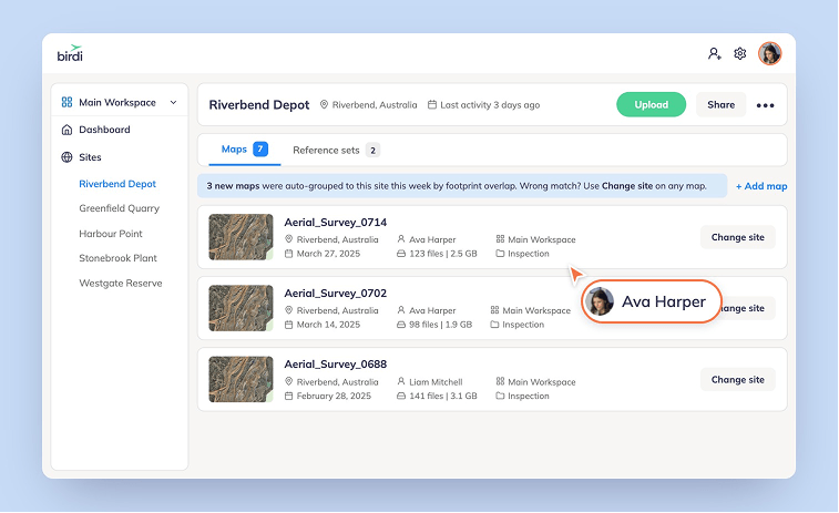
In Birdi (birdi.io), a site is the unit. You create it once, with an address, a boundary and an image, and every map flown there joins it automatically. It keeps the site's surveys and surfaces together, plus its survey control on Ultimate, so each survey starts from the last. Sites are available on all paid plans.
The steps, from Birdi's guide to using Sites:
- Create a site from the dashboard sidebar or the Map Browser, with an address, a boundary and a site image.
- Let maps group themselves. New maps are matched to a site by where they were flown, based on their footprint. If one lands in the wrong place, use Change site on that map.
- Assign existing maps, or unassign them, at any time.
- Start the next survey from the site, bringing across earlier DEMs. On the Ultimate plan, the site's GCP and prism reference sets come too.
- Share the site with your team, so everyone opens the same history.
What should you look for in a tool for repeat surveys?
Look for a tool that treats the place as the unit: surveys grouped by location without manual filing, control and surfaces that carry into the next survey, survey dates rather than upload dates, and access for the people who need the history. It should also make comparing two surveys a step, not a project.
If your team flies the same sites repeatedly and wants the history in one shared workspace, Birdi is a sensible option for construction and mining teams. A surveyor who wants full control of photogrammetry processing, or an analyst working mainly in a desktop GIS, may prefer to organize data there instead.
Frequently asked questions
How are drone maps matched to a site?
It depends on the tool. Some match a map to a site by where it was flown, comparing the map's footprint with the site's boundary. Others rely on folders or naming you apply yourself. Automatic matching saves filing time, but check that you can move a map that lands in the wrong site.
Can I move existing surveys into a site?
Usually, yes. Most tools let you assign existing maps to a site and unassign them later, so you can organize a backlog of earlier surveys as well as new ones. Start with the sites you fly most often, because that is where finding and comparing surveys takes the most time.
What should I name repeat drone surveys?
Put the capture date first, in year-month-day order, followed by the site and a short purpose, such as progress or stockpiles. Dates in that order sort correctly. However, once surveys are grouped by site, names matter less, because the site already tells you where each one belongs.
How often should I fly the same site?
Fly as often as the question needs. Active earthworks and stockpiles are often captured weekly or monthly. Construction progress is often monthly, matched to reporting. Monitoring work follows its monitoring plan. Flying more often than the site changes mostly produces surveys nobody compares, so match the schedule to decisions.
Can people outside the survey team see a site's history?
That depends on the tool and your permissions. In a shared workspace, project managers, engineers and owners can open the same site, see its surveys in order and compare them. Check what access each role gets, and whether people outside the paid team can view without a full seat.
About the author
This guide was written by the Birdi team. Birdi (birdi.io) is a geospatial AI workspace that construction and mining teams use to share drone, 360 and design data in one map. The survey findings come from the sources listed below, and Birdi's steps come from its own help center, read on September 28, 2026.
Related reading
- Single source of truth: why one shared record beats scattered files.
- Visibility across multiple sites: running several sites from one view.
- Sites and geotechnical monitoring: the release that introduced Sites.
Sources
- PlanGrid and FMI. "New Research from PlanGrid and FMI Identifies Factors Costing the Construction Industry More Than $177 Billion Annually" (Construction Disconnected 2018 industry report). PR Newswire, August 1, 2018. https://www.prnewswire.com/news-releases/new-research-from-plangrid-and-fmi-identifies-factors-costing-the-construction-industry-more-than-177-billion-annually-300689826.html
- Atik, M. and Arkali, M. "Comparative Assessment of the Effect of Positioning Techniques and Ground Control Point Distribution Models on the Accuracy of UAV-Based Photogrammetric Production." Drones 9 (1), 15, 2024. https://doi.org/10.3390/drones9010015
- van der Sluijs, J., Fraser, R. H. and Lantz, T. C. "Replicability of Digital Terrain Models and Canopy Height Models Derived from Drone Photogrammetry." Remote Sensing 18 (4), 627, 2026. https://doi.org/10.3390/rs18040627
- Birdi. "How to use Sites in Birdi." Birdi Help Center, read September 28, 2026. https://help.birdi.io/en/articles/16767430-how-to-use-sites-in-birdi