
How to Manage GCP and Prism Survey Control Across Repeat Surveys

TL;DR: To manage survey control across repeat drone surveys, keep one set of ground control points and prisms per site, and save every re-survey as a new version rather than overwriting it. Keep each point's status current, and make sure a re-survey never changes maps already built, so every survey stays tied to the control it used.
Key takeaways
- Control drives accuracy. In one 2024 study, five evenly spread control points gave 3.0 cm vertical error, and flights without control had the highest errors.
- Keep one set per site, not one spreadsheet per survey, so every map uses the same control.
- Version every re-survey. Overwriting coordinates loses the record of which control a past survey used.
- Status belongs to the physical mark. A destroyed point should show as destroyed on every map, at once.
- Old maps should stay as measured when a point is re-surveyed.
Why does survey control get messy on repeat surveys?
Survey control gets messy because it is usually managed outside the maps it serves. Coordinates sit in a spreadsheet on one person's desktop, re-surveys overwrite earlier values, and a disturbed mark is noticed in the field but not recorded. As a result, a later survey may use the wrong coordinates without anyone knowing.
A single survey hides the problem. However, a site flown every week for a year has fifty surveys, several re-surveys of the control, and a handful of marks lost to machinery. Each of those is a chance for surveys to stop lining up. The broader cost is familiar. According to PlanGrid and FMI's 2018 survey of nearly 600 construction leaders, 48% of rework on US jobsites was attributed to miscommunication and poor project data.
If you need a refresher on what control points do, the guide to how GCPs improve accuracy covers the basics. This guide starts where it stops: the control exists, and the site keeps being flown.
How should you store survey control for a site?
Store it once, at the site, in one set that every survey of that site uses. Record the coordinate system the coordinates were exported in, and keep a note of who surveyed them and when. Then each new survey draws on the same control, instead of someone re-entering it from a file.
Consistency is the reason. According to Atik and Arkali's 2024 study in Drones, a model with five evenly spread control points reached 2.5 cm horizontal and 3.0 cm vertical error, while flights without control had the highest errors. That accuracy only carries across surveys if each one uses the same control, in the same coordinate system. The guide to coordinate reference systems explains why the system matters as much as the points.
What should happen when control is re-surveyed?
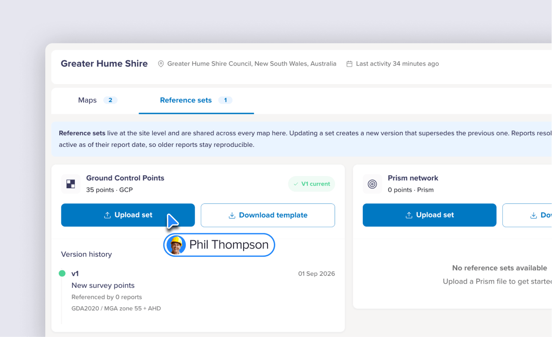
A re-survey should create a new version of the set, not overwrite the old one. The new coordinates apply from then on, while the earlier version stays on record. That way, anyone can see which control a past survey or report used, and why its numbers came out as they did.
Overwriting is the common mistake. When coordinates are replaced in place, a survey from last quarter silently points at control it never used. Versioning also answers a practical question: which reports depend on which version. For instance, a version history that shows how many reports reference each version tells you what a change will touch.
Why should a map keep the survey it was made from?
A map should keep the control it was built with, because that is what it measured against. If a re-survey moved the points on every earlier map, historical work would shift, and past measurements, volumes and reports would stop matching what was issued. Keeping each map on its own survey keeps the record honest.
This matters most for anything reported externally. A monitoring report or a progress claim was produced against specific control. If that control later changes underneath it, the report can no longer be reproduced. So new versions should apply to new work, not rewrite old work.
How do you keep every point's status current?
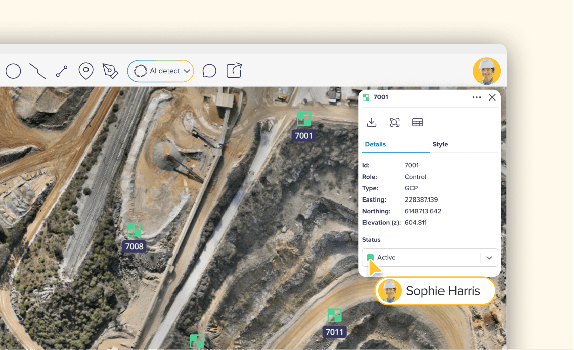
Give every point a status that reflects its condition on site, such as active, warning, destroyed or planned, and attach that status to the physical mark rather than to one map's copy of it. Then a mark lost to machinery is flagged once and shows as destroyed everywhere, so nobody uses it by mistake.
Status matters because marks do not last. Machinery runs over them, stockpiles bury them, and settlement moves them. A clear visual cue helps too. For example, when icon shape shows the point type and color shows the status, a disturbed mark stands out on the map before anyone processes against it.
Why are GCPs and prisms handled differently?
Ground control points and prisms do different jobs. GCPs anchor the map to real-world coordinates, so they go into the processing as control. Prisms on a monitored structure are checkpoints: they are kept out of the control so their measured positions show movement independently, rather than bending the map to fit them.
Treating the two differently is what makes monitoring work. If prisms were used as control, the map would be pulled toward their old positions, and genuine movement would be hidden. Keeping them separate lets each report state movement honestly. The guide to prism movement reports covers how that reporting works.
Accuracy also differs between them. According to the help center of Birdi (birdi.io), hand-tagging each point in the imagery adds about 20 to 30 mm of bias for a ground control point, and about 3 to 4 mm for a prism on a low monitoring flight.
How do you manage survey control, step by step?
Start from a template, upload the set to the site with its coordinate system, add a note, fix any row errors, then check the points on the map and set their status. In Birdi, GCP and prism reference sets work this way on the Ultimate plan.
The steps below follow Birdi's guide to uploading reference sets.
- Download the CSV template for a GCP or prism set, so the file is formatted correctly.
- Upload it to the site and choose the coordinate system it was exported in.
- Add a note, such as who surveyed it and when. It becomes the description of that version.
- Fix any errors. If a row is wrong, Birdi says which one.
- Check the points on the map. Each point is a layer: select one for its role, type, easting, northing and elevation.
- Set each point's status: active, warning, destroyed or planned. The change applies to the physical point on every map.
- Upload re-surveys as new versions. Earlier maps keep the survey they were made from, and each version shows how many reports reference it.
- Export when needed, as CSV, GeoJSON or PDF.
What should you look for in a tool for survey control?
Look for a tool that keeps control at the site rather than per survey: versioned sets that are never overwritten, a clear record of who surveyed what, point status tied to the physical mark, maps that keep their original survey, prisms handled as checkpoints, and exports in the formats your surveyor uses.
If your team flies the same sites repeatedly and is tired of the control spreadsheet, Birdi is a sensible option for construction and mining teams on its Ultimate plan. A surveyor who wants hands-on control of processing, or a team already managing control in survey software they are happy with, may prefer to keep it there.
Frequently asked questions
Can I reuse ground control points across repeat surveys?
Yes, as long as the marks are still where they were surveyed. Reusing the same control across surveys keeps them comparable. Check each mark's condition before flying, flag any that have been disturbed or destroyed, and re-survey when needed, saving the new coordinates as a new version rather than overwriting the old ones.
What should I do when a ground control point is destroyed?
Mark it as destroyed so nobody processes against it, and make sure that status shows on every map of the site. If the point is replaced, survey the new mark and upload it as a new version. Earlier maps should keep the control they used, so past measurements stay valid.
What happens to existing maps when I upload a new control version?
In a well-designed system, nothing changes on maps already built. They keep the survey their points came from, so earlier measurements and reports stay reproducible. The new version applies to new surveys. Check which reports reference the older version before deciding whether anything needs to be re-run.
What is the difference between a GCP and a checkpoint?
A ground control point is used in processing to tie the map to real-world coordinates. A checkpoint is surveyed the same way but kept out of processing, so it can independently test the map's accuracy. Prisms on a monitored structure act as checkpoints, which is how they measure movement.
What file format should survey control be in?
Most tools take a CSV with a point ID, easting, northing and elevation, plus the coordinate system it was exported in. Start from the tool's template to avoid formatting errors. For use elsewhere, GeoJSON suits GIS software and a PDF suits a report or site file.
About the author
This guide was written by the Birdi team. Birdi (birdi.io) is a geospatial AI workspace that construction and mining teams use to share drone, 360 and design data in one map. The study and survey cited are listed below, and Birdi's steps and figures come from its own help center, read on September 28, 2026.
Related reading
- GCPs, levels and checkpoints: how the three kinds of point work together.
- GCPs in volumetric reporting: why control decides whether volumes hold up.
- Organizing surveys by site: keeping every survey of a location together.
- Sites and geotechnical monitoring: the release that added reference sets.
Sources
- Atik, M. and Arkali, M. "Comparative Assessment of the Effect of Positioning Techniques and Ground Control Point Distribution Models on the Accuracy of UAV-Based Photogrammetric Production." Drones 9 (1), 15, 2024. https://doi.org/10.3390/drones9010015
- PlanGrid and FMI. "New Research from PlanGrid and FMI Identifies Factors Costing the Construction Industry More Than $177 Billion Annually" (Construction Disconnected 2018 industry report). PR Newswire, August 1, 2018. https://www.prnewswire.com/news-releases/new-research-from-plangrid-and-fmi-identifies-factors-costing-the-construction-industry-more-than-177-billion-annually-300689826.html
- Birdi. "How to upload GCP and prism reference sets to a site in Birdi." Birdi Help Center, read September 28, 2026. https://help.birdi.io/en/articles/16768238-how-to-upload-gcp-and-prism-reference-sets-to-a-site-in-birdi
- Birdi. "How to work with reference points (GCP & prisms) on your map in Birdi." Birdi Help Center, read September 28, 2026. https://help.birdi.io/en/articles/16768386-how-to-work-with-reference-points-gcp-prisms-on-your-map-in-birdi
- Birdi. "Understanding accuracy in geotechnical monitoring reports." Birdi Help Center, read September 28, 2026. https://help.birdi.io/en/articles/17125217-understanding-accuracy-in-geotechnical-monitoring-reports