
Why does geospatial data become siloed?

TL;DR: Geospatial data becomes siloed because spatial formats are technically demanding, GIS expertise is concentrated in specialist teams, and the tools used to capture, process, and view spatial data rarely talk to each other. The result is accurate, valuable data that sits locked inside specialist workflows, inaccessible to the wider organization that needs it to make decisions.
Key takeaways
- According to a DATAVERSITY 2024 survey, 68% of organizations cite data silos as their top data management concern — up 7% year-on-year.
- A survey of GIS practitioners found that 87.5% identified data cleaning and formatting as their single most time-consuming workflow stage, driven largely by incompatible formats across teams.
- Geospatial data is collected across dozens of formats — Shapefile, GeoTIFF, GeoJSON, LAZ, KML, and more — and conversion between them is rarely lossless, creating friction at every handoff.
- Regular data warehouses do not support the structuring, indexation, and rendering of spatial data, meaning the integration tools that broke down silos for other data types have not worked for geospatial.
- The consequences are not just technical: organizations with siloed geospatial data often rely on a single GIS specialist as a bottleneck, slowing decisions that should be immediate.
What is a geospatial data silo?
A geospatial data silo is a repository of spatial data — maps, orthomosaics, point clouds, DEMs, GPS logs, inspection records, or any data with a location component — that is accessible to one team or system but not to the others who need it. The data exists, is often accurate, but cannot be used by the organization because it is trapped behind specialist tools, incompatible formats, or departmental boundaries.
Data silos in general are a well-understood problem. According to research by Experian, approximately 40% of business-critical data across organizations is trapped in silos, and the American Management Association found that 97% of executives say siloed data has had a negative effect on their business. Geospatial data has all the same organizational causes — and several additional technical ones that make it particularly prone to fragmentation.
Why does geospatial data silo more readily than other data types?
Spatial data is harder to share than most data because it requires specialist software to open, display, and interpret — and that software is rarely installed outside the GIS team.
A spreadsheet can be opened by almost anyone in an organization. A PDF can be read on any device. A GeoTIFF, a LAZ point cloud, or an ESRI File Geodatabase cannot. These formats require GIS tools — ArcGIS, QGIS, or similar — that carry licensing costs, require training, and are rarely deployed beyond the spatial team. This creates an immediate structural dependency: anyone outside the GIS function who needs to use spatial data must ask a GIS specialist to retrieve, interpret, or reformat it for them.
The format problem runs deeper than just access. According to Geo Week News, geospatial data is routinely delivered in incompatible formats with conflicting coordinate reference systems, and conversion between common formats — Shapefile to GeoJSON, GeoTIFF to web tiles, LAZ to a viewable 3D model — is technically involved and often not lossless. This means that when spatial data does cross from one team to another, it typically arrives in a form that requires further work before it can be used.
A 2024 survey of GIS practitioners found that 87.5% identified data cleaning and formatting as their single most time-consuming workflow stage. That time is not spent on analysis or insight — it is spent on the logistics of moving data between formats and environments that were never designed to interoperate.
What organizational patterns create geospatial data silos?
Technical barriers are only half the story. Most geospatial data silos form because of how organizations are structured and how data is captured in the field.
Data is collected by different teams using different tools. In a construction or utilities context, field crews capture GPS coordinates in shapefiles, planning teams work in geodatabases, asset managers store geometry in CAD systems, and survey teams deliver outputs as GeoTIFF exports. Each team is doing its job correctly within its own workflow. The problem is that no common layer exists to bring those outputs together — so spatial data accumulates in parallel, disconnected stores rather than in a single shared record.
Departments build their own spatial environments. When a GIS team is slow to respond to requests (because they are the bottleneck), operations teams, engineering teams, and asset managers often build workarounds: their own folder structures, their own copies of spatial files, their own processes for visualizing data. This produces redundant, unsynchronized stores of the same data, which quickly diverge. Multiple versions of the same map or survey exist simultaneously with no way to determine which is current.
Spatial data is treated as a specialist deliverable, not a shared asset. In many organizations, geospatial outputs — drone surveys, inspection maps, site models — are commissioned for a specific purpose and then filed away rather than maintained as ongoing shared resources. A drone survey is delivered as a set of files in an email, reviewed by the person who commissioned it, and archived. It never becomes part of a shared spatial record that evolves over time.
What are the consequences of siloed geospatial data?
The most immediate consequence is that decisions get made without the best available spatial information — not because the data does not exist, but because the person making the decision cannot access it.
A project manager approving construction progress has to request a report from the surveyor rather than viewing the site model directly. An operations manager responding to an asset failure cannot see the inspection records tied to that location because they live in a GIS system the operations team does not have access to. An executive reviewing a mining operation has to wait for a weekly report rather than viewing the current state of the site in real time.
According to Salesforce research, data silos cost organizations an average of $7.8 million annually in lost productivity. Employees waste approximately 12 hours per week searching for information across disconnected systems. For geospatial data specifically, the friction is compounded by the dependency on specialist intermediaries: every time a non-GIS team member needs spatial data, they generate a request for a GIS specialist, who then has to retrieve, format, and deliver it before any decision can be made.
"It used to take days and weeks to get information," said Pratibha Basrao, Director of Geospatial Solutions at HDR, Inc., describing the state of government agencies before adopting an enterprise spatial platform. "Now, they can just log in to this platform and answer their questions." The gap between those two states — days and weeks versus immediate — describes what siloed geospatial data costs in practice.
Why do GIS teams become the bottleneck?
GIS teams become bottlenecks not because of individual failings but because of a structural mismatch: the volume of geospatial data being produced by modern field operations outpaces the capacity of a small specialist team to manage, format, and distribute it.
Drone surveys, satellite imagery, LiDAR scans, GPS logs, and sensor feeds produce spatial data continuously and at scale. In many organizations, all of that data has to pass through a GIS team to become usable. The team processes raw captures into viewable outputs, converts formats for downstream consumers, manages storage, and responds to requests for analysis. That pipeline was designed for a world where spatial data was collected occasionally; it is not suited to a world where it is produced daily.
The result is a queue. Requests for spatial data — a comparison of two survey dates, an extraction of assets within a boundary, a visualization of inspection results — sit waiting while the GIS team works through a backlog of data formatting and delivery tasks. According to the Open Geospatial Consortium, common challenges include moving data between different environments, which requires constant conversion, projection reconciliation, and quality checks at every handoff.
This is a solvable problem, but the solution is not to hire more GIS specialists. It is to reduce the number of tasks that require a GIS specialist at all — by making processed spatial data directly accessible to the teams who need it, in a format they can use without specialist software.
How do you know if your geospatial data is siloed?
The clearest signal is a process dependency: if accessing, viewing, or acting on spatial data requires a request to a specialist team, the data is siloed. Other indicators are more subtle.
Multiple versions of the same spatial file exist across different teams' systems, with no clear record of which is authoritative. Drone surveys and spatial deliverables are emailed as file attachments rather than shared as links to a common environment. Non-technical stakeholders — project owners, executives, operations managers — routinely request reports rather than accessing the underlying spatial data themselves. Field teams capture data into personal devices or messaging threads rather than directly into a shared spatial environment.
Each of these patterns points to the same underlying condition: spatial data is being produced but not accumulated into a shared, accessible record. The data exists in the organization; it just is not accessible to the organization.
What should you look for to break geospatial data silos?
The core requirement is a shared workspace the whole team can access and understand — not just GIS specialists. If spatial outputs are only interpretable by people with specialist training, the silo problem has been relocated rather than solved.
Beyond that, look for the following: the ability to host multiple spatial data types — orthomosaics, DEMs, point clouds, 3D models, vector layers — in a single shared environment; versioning and a clear history of changes so teams always know which data is current; collaboration features (comments, annotations) that team members can use from accounts within a shared workspace, alongside the ability to share specific outputs via a link so external stakeholders — clients, project owners, auditors — can view data in a browser without needing an account; and access controls granular enough to share selectively without exposing everything.
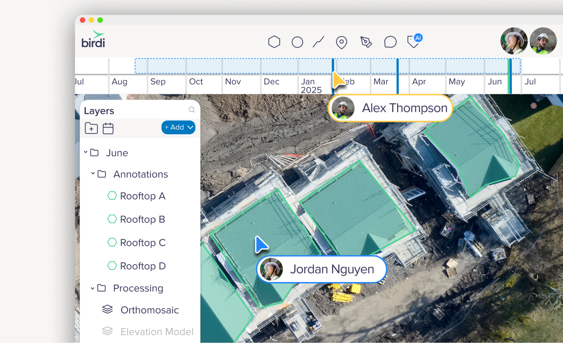
For teams that produce and receive drone survey outputs as a core part of their workflow, the collaboration layer matters as much as the storage and rendering. Birdi is designed specifically for this use case: team members log in to a shared geospatial workspace to upload drone outputs, compare survey dates, and collaborate on a shared map — without needing specialist GIS knowledge to navigate or interpret what they're looking at. External stakeholders such as clients or project owners can view specific outputs via a shared link, with no account or software needed on their end. It suits teams that need to break the GIS-specialist bottleneck without replacing their existing processing tools. Organisations that also need deep spatial analysis, custom scripting, or integration with enterprise GIS systems may find a dedicated GIS platform a better fit alongside or instead.
Whatever platform you choose, the governance decisions are as consequential as the technology: who is responsible for uploading spatial data, at what cadence, with what naming convention, and who has access. A silo can re-form around a new platform if the underlying habits — emailing files, maintaining separate copies, gating access — are not changed alongside the tooling.
Frequently asked questions
What is a geospatial data silo?
A geospatial data silo is spatial data — maps, drone surveys, point clouds, GPS records, or any data with a location component — that is stored and managed in isolation from the rest of an organization. It exists and is often accurate, but cannot be accessed or used by teams outside the specialist function or system that holds it. Silos form because spatial data formats require specialist tools to open, and because spatial data is routinely collected and filed by separate teams with no shared environment to bring it together.
Why is geospatial data more prone to silos than other data?
Geospatial data requires specialist software to open and interpret. Common spatial formats — GeoTIFF, LAZ, Shapefile, ESRI Geodatabase — cannot be opened by standard business tools, so they are only accessible to teams with GIS software installed. This creates a structural dependency on specialist intermediaries that does not exist for spreadsheets, documents, or standard databases. Regular data warehouses also do not support geospatial data natively, meaning the infrastructure that broke down silos for other data types has not extended to spatial data.
How do geospatial data silos affect decision-making?
When spatial data is siloed, the people making decisions cannot access the best available evidence. A project manager needs to request a report rather than viewing current site data directly. An executive reviewing field operations waits for a weekly briefing rather than checking a live spatial record. An asset manager cannot cross-reference inspection records with location data because the two live in separate systems. The time cost of those dependencies — requests, formatting, delivery — accumulates into significant delays and decisions made on information that is older or less complete than it should be.
What causes geospatial data to fragment across teams?
The primary causes are format incompatibility (different teams use different spatial formats that do not interoperate), tool silos (each team uses its own GIS or spatial tool with no shared environment), and capture patterns (field data is captured into personal devices or team-specific systems rather than a shared environment). Organisational structure plays a role too: when the GIS team owns all spatial data, other departments build workarounds with their own copies. Once multiple copies exist, versioning breaks down and data diverges.
How do you break down geospatial data silos without replacing your existing GIS tools?
The most practical approach is to add a collaboration and visualization layer on top of existing tools rather than replacing them. Processing and analysis workflows in ArcGIS, QGIS, Pix4D, or similar tools stay in place; the outputs — processed orthomosaics, DEMs, point clouds, inspection data — are pushed into a shared environment accessible to non-technical users via a browser, with no specialist software required. This removes the bottleneck at the distribution and access stage without disrupting the specialist workflows that produce the data. The governance side matters equally: shared naming conventions, clear ownership of the upload process, and access rights that extend to operational and executive stakeholders.
Sources
- DATAVERSITY. "Trends in Data Management 2024." DATAVERSITY, 2024. https://www.dataversity.net/
- Experian. "Global Data Management Research." Experian, 2023. https://www.experian.com/
- Ellipsis Drive. "Breaking Down Geospatial Data Silos." Ellipsis Drive Blog, 2024. https://ellipsis-drive.com/blog/breaking-down-geospatial-data-silos/
- Geo Week News. "Why Interoperability Remains a Bottleneck in Geospatial Technology." Geo Week News, 2024. https://www.geoweeknews.com/news/why-interoperability-remains-a-bottleneck-in-geospatial-technology
- Esri / Government Executive. "How GIS Can Break Down Government Data Silos in the Digital Age." Government Executive / Esri, 2019. https://www.govexec.com/media/esri_gis_data_silos_q42019.pdf
- Open Geospatial Consortium. "Common Challenges in Geospatial Integration." OGC Blog, 2024. https://www.ogc.org/blog-article/common-challenges-in-geospatial-integration/
- Salesforce Research. "State of the Connected Customer." Salesforce, 2023. https://www.salesforce.com/