
What is geospatial AI (GeoAI)?

Geospatial AI — often shortened to GeoAI — is becoming a core part of how spatial data is analyzed and understood. As organizations collect more drone imagery, orthomosaics, and satellite data, the challenge is no longer access to information. It’s making sense of it quickly, consistently, and at scale.
GeoAI brings artificial intelligence into geospatial workflows to help teams interpret location-based data more efficiently. Instead of relying entirely on manual review, geoAI supports tasks like identifying patterns, comparing change over time, and highlighting areas that deserve closer attention.
.png)
What is geospatial AI?
Geospatial AI (GeoAI) is the use of artificial intelligence to analyze and interpret location-based data such as maps, drone imagery, satellite imagery, or other geospatial datasets. It combines machine learning, computer vision, and spatial analysis to help teams identify patterns, detect features, and understand change more efficiently.
How does GeoAI work?
GeoAI sits at the intersection of several technologies:
- Machine learning, trained on large volumes of spatial or imagery data
- Computer vision, used to interpret visual information in images, maps, and orthomosaics
- Spatial reasoning, which accounts for scale, terrain, and geographic relationships
- Temporal analysis, allowing comparisons across time
In practice, GeoAI systems learn from large collections of labelled spatial data. For example, imagery where certain features or conditions have already been identified. Over time, models learn not just what something looks like, but how it behaves in space — how it relates to terrain, nearby features, and historical context.
This spatial awareness is what separates GeoAI from traditional image analysis. A road isn’t just a visual pattern. It connects places, follows terrain, and changes over time. GeoAI models are designed to account for those relationships, which makes them far more useful for real-world geospatial work.
This is also why research organizations like IBM are developing AI models built specifically for Earth observation. Their recent work on foundation models trained on multispectral and multi-temporal data reflects a broader shift toward AI that understands the physical world, not just pixels.
Why is GeoAI becoming so important?
Several changes are happening at once.
The volume of spatial data is growing rapidly
Drones, satellites, and sensors are generating imagery and spatial data at a scale that manual review can’t realistically keep up with.
AI is better at interpreting the physical world
Modern models can now handle complex visual and spatial patterns with far more reliability than even a few years ago.
Organizations want insight, not just imagery
As GeoWeek notes, GeoAI is driving “the next generation of geospatial insights” by helping teams move from raw data to understanding, faster and more consistently.
Together, these shifts explain why GeoAI is moving from experimental to operational in many industries.
Some GeoAI use cases and how it improves geospatial workflows
GeoAI isn’t about replacing expertise. It’s about making everyday geospatial work more manageable and less time-intensive.
Some of the workflows GeoAI can improve include:
Faster, more focused inspections
Large image sets and orthomosaics can take hours to review manually. GeoAI can help surface areas that deserve attention earlier in the process, so teams spend less time searching and more time assessing.
Highlighting meaningful change between surveys
Comparing datasets across time is one of the most common geospatial tasks. GeoAI can support workflows that focus on what’s changed — whether that’s vegetation movement, construction progress, erosion, or landform shifts.
Supporting environmental and land monitoring
Repeatable classification and comparison tasks are often tedious and inconsistent when done manually. GeoAI can assist by providing a more standardized starting point.
Improving consistency across teams
Different people can interpret the same imagery differently. AI-assisted review helps reduce that variability, especially across large or distributed teams.
Speeding up feature identification
Even simple AI-supported identification of visible patterns or areas can significantly reduce manual effort in inspections, assessments, or site reviews.
Across all of these examples, the goal isn’t automation for its own sake. It’s about reducing the time between data capture and understanding — and lowering the risk of missing something important in large or complex datasets.
Why GeoAI only matters when it changes outcomes
As GeoAI matures, there’s growing recognition that detection alone is no longer the hard part. Finding features in imagery is becoming increasingly accessible.
What’s harder is everything that comes after.
Turning outputs into something teams can trust. Comparing results over time. Explaining why something matters. Helping people decide whether action is needed.
At Birdi, this belief shapes how we think about geospatial AI. GeoAI only creates value when it reduces work, reduces risk, or helps teams make clearer decisions together. In real operational environments, insight — not novelty — is what determines impact.
How Birdi fits into the GeoAI landscape
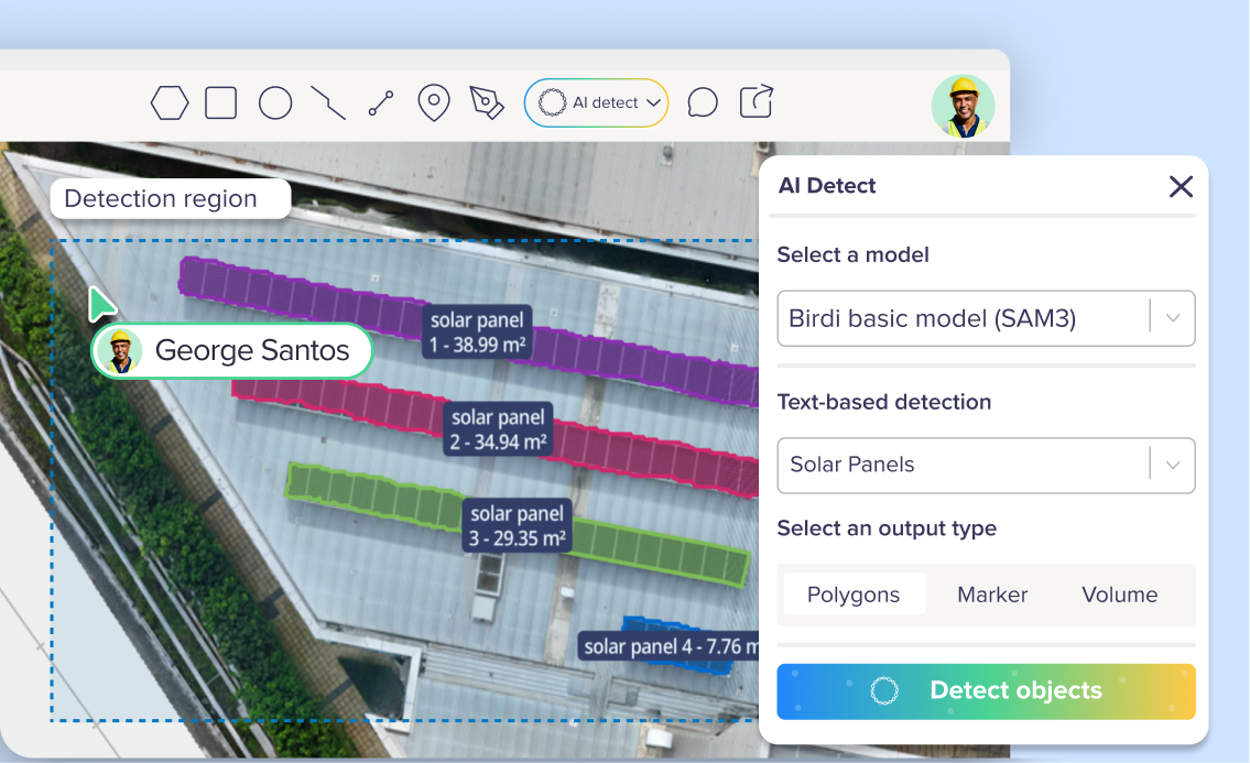
Birdi is built around helping teams turn complex geospatial data into shared understanding. This includes AI-assisted capabilities such as AI Detect, which supports analysis across both individual images and maps or orthomosaics.
Rather than treating GeoAI as a standalone feature, Birdi focuses on how AI fits into real workflows — helping teams review imagery faster, surface insights earlier, and collaborate around the same spatial context.
As the GeoAI landscape continues to evolve — from new Earth Observation foundation models to more accessible computer-vision tools — Birdi’s role remains focused on making those capabilities usable, practical, and aligned with how teams actually work.
What’s next for GeoAI?
The next phase of GeoAI is likely to be shaped by models trained specifically on Earth Observation data. These models are expected to improve performance across different environments, reduce sensitivity to local conditions, and make AI outputs more transferable across regions.
For organizations working with land, infrastructure, or environmental data, this means GeoAI will increasingly support long-term monitoring, risk assessment, and decision-making — not just one-off analysis.
___
Geospatial AI is quickly becoming a foundational technology for working with spatial data. As datasets grow and expectations around speed and accuracy rise, GeoAI will play a central role in helping teams understand what’s happening on the ground — and what’s changing over time.
The real value of GeoAI isn’t in what it can detect. It’s in how clearly teams can understand what they’re seeing, together, and act with confidence.