
How georeferencing and metadata make maps accurate


Geospatial data is only useful if it knows where it belongs. That’s the simple idea behind georeferencing—a process that connects your maps, drone images, or scanned plans to real-world locations. Without it, you’re basically working with floating data that can’t be measured, overlaid, or trusted.
So whether you're mapping a mine site, monitoring erosion, or just trying to line up a few layers correctly, georeferencing is what makes spatial data accurate and usable.
.png)
What is georeferencing?
Georeferencing is the process of aligning spatial data—like drone imagery or scanned maps—to real-world coordinates. It allows you to place that data accurately on a map so it can be measured, analyzed, and compared with other geospatial layers. This alignment relies on metadata such as the coordinate system, projection, and resolution of the data.
Why does georeferencing matter?
Imagine flying a drone over a construction site. You capture a high-res image of the area, but when you open it on your computer, there’s no context—no coordinates, no way to overlay it on other maps or measure distances. Georeferencing fixes that by telling the image where it sits on the Earth’s surface.
Once the image is georeferenced, it can:
- Line up accurately with other spatial data (e.g. existing site plans or topographic layers)
- Be used to take real-world measurements like distance, area, and volume
- Feed into change detection or compliance reporting workflows
Without georeferencing, your data isn’t grounded—and that means it’s not reliable for decision-making.
The role of metadata
Georeferencing relies heavily on metadata: the behind-the-scenes info that tells us how to interpret the spatial data. If you’ve ever opened a drone image and seen information about the GPS location, altitude, camera settings, or coordinate reference system, that’s metadata at work.
Some key types of geospatial metadata that support georeferencing include:
- Coordinate system (e.g. WGS84, GDA2020)
- Projection (e.g. UTM zone, MGA zone)
- Altitude type (ellipsoidal or geoidal)
- Capture date and time
- Camera position and angle
- Pixel resolution
Most modern mapping platforms, including Birdi, read this metadata automatically during processing. That means when you upload drone images captured with GPS-enabled cameras, the system can georeference them for you—no manual work required.
Common georeferencing methods
Depending on the type of data you’re working with, georeferencing can happen in a few different ways:
1. Automatic georeferencing
Drone photos and satellite images often come with embedded GPS data in the metadata. If you're using a mapping platform like Birdi, it reads this information and places the imagery correctly on a map during processing.
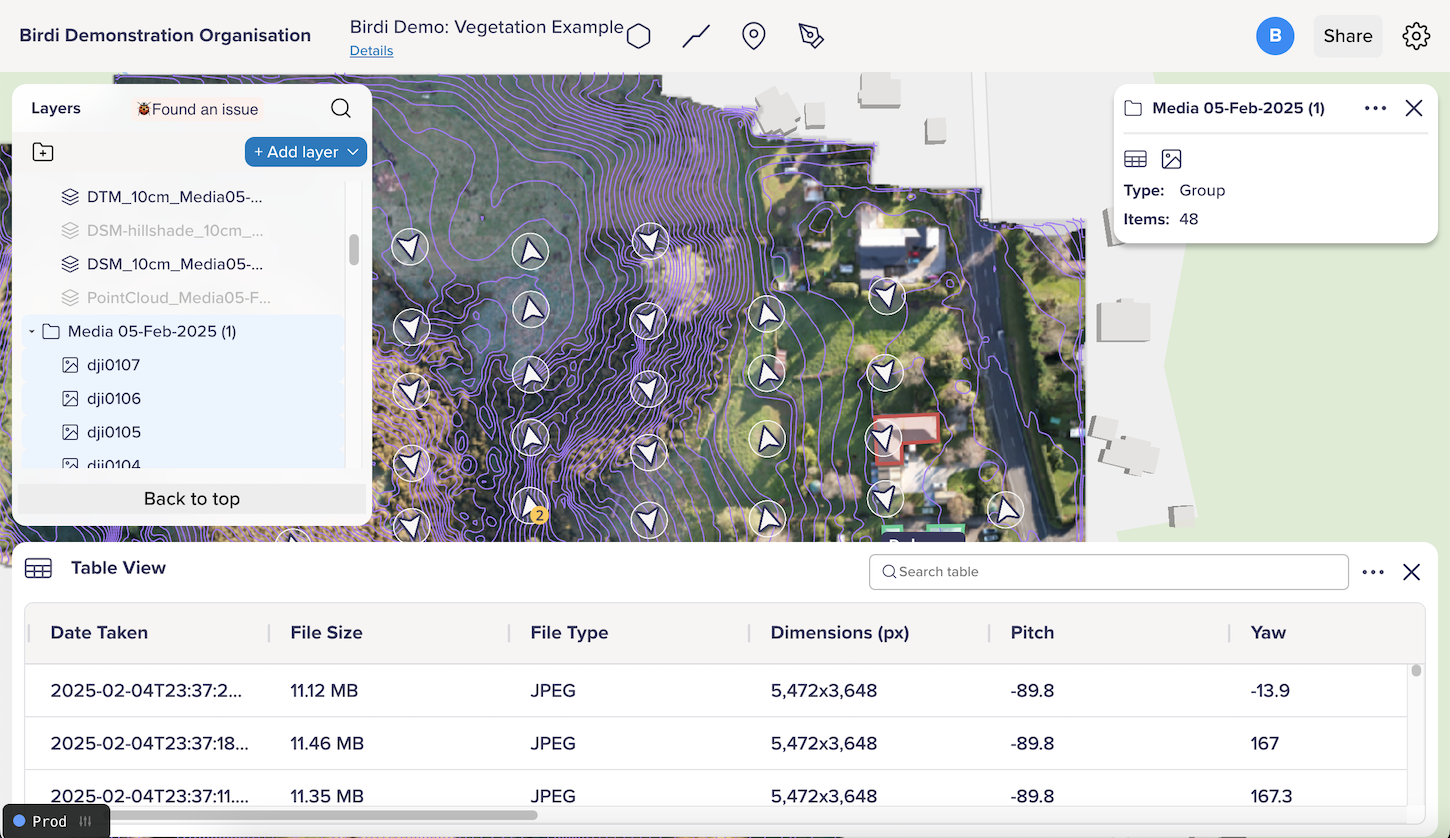
You can view your image metadata in Birdi's table view:
2. Ground Control Points (GCPs)
For projects that need higher precision—like engineering surveys or volumetric analysis—GCPs can be used. These are known points on the ground with accurate coordinates that are marked in the imagery to increase georeferencing accuracy.
3. Manual georeferencing
This is often used for older maps or scanned plans that don’t include location metadata. You manually match features in the image to real-world coordinates using control points (e.g. a road intersection or building corner).
What happens if your data isn’t georeferenced?
In short: things won’t line up. You might experience:
- Layers that don’t match up visually
- Incorrect measurements
- Problems with reporting or spatial analysis
- Miscommunication between teams
For example, imagine overlaying unreferenced drone imagery on an existing site layout—it might look close, but it could be off by meters. That can be a big problem when making decisions about earthworks, vegetation removal, or utility inspections.
Georeferencing in Birdi
At Birdi, georeferencing happens automatically when users upload drone imagery with location metadata. Users on higher plans can also:
- Specify custom coordinate systems and projections
- Use Ground Control Points for high-precision processing
- Export orthomosaics, DEMs, contours, and more with accurate spatial alignment
___
Georeferencing is what takes your imagery from "just a picture" to a useful spatial layer. Combined with accurate metadata, it ensures your geospatial outputs are reliable, measurable, and aligned with the real world.
If you're capturing data in the field, always make sure your equipment is recording location information—and check that your platform is reading that metadata correctly when you upload. It might seem like a background process, but it's the backbone of everything you do in mapping.