
Birdi’s file uploader just got a major upgrade

Anyone working with geospatial data knows the upload step can become surprisingly painful.
A single project might include raw drone imagery, orthomosaics, point clouds, vectors, PDFs, reports, spreadsheets, and supporting files spread across different folders, cloud drives, and devices. Before uploading, teams often spend unnecessary time renaming files, sorting folders, and trying to keep datasets organised so they don’t become chaos later.
With Birdi’s redesigned upload experience, that extra prep work largely disappears.
Instead of forcing users to structure everything perfectly ahead of time, Birdi now helps make sense of the data after upload — automatically organising files into a clearer, more structured workspace.
One upload workflow for everything

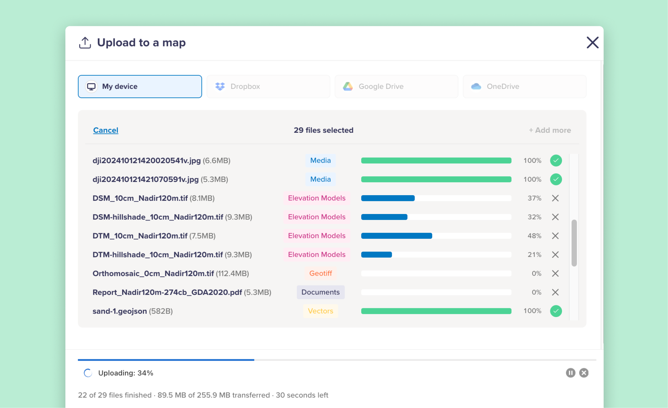
The new uploader combines all supported upload types into a single streamlined workflow.
Rather than switching between separate upload tools for imagery, vectors, documents, or 3D files, everything now happens through one unified “Upload files” experience directly inside the map workspace.
You can now upload:
- Raw drone imagery
- Orthomosaics and GeoTIFFs
- DEMs and raster outputs
- Point clouds and meshes
- Vector data like KML, GeoJSON, SHP, and DXF
- PDFs and reports
- Videos and 360° imagery
- Supporting project files and spreadsheets
Uploads can come from:
- Local devices
- Google Drive
- Dropbox
- OneDrive
The goal wasn’t just to support more file types. It was to reduce friction for teams managing large amounts of mixed geospatial data.
Upload data how you already work
One of the biggest changes is flexibility.
Previously, many teams felt they needed to organise everything carefully before uploading to keep projects manageable. But in reality, field data collection rarely happens in a perfectly structured way.
Some files come from pilots. Others come from consultants, surveyors, GIS teams, or external contractors. Data might live across cloud drives, phones, hard drives, or exported processing folders.
Birdi’s new uploader is designed around that reality.
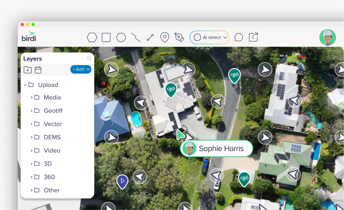
Instead of forcing users into rigid upload structures, Birdi now automatically detects file types and organises them into relevant folders and subfolders after upload. That means users can spend less time preparing data and more time actually working with it.
For example:
- Drone imagery can automatically group together
- Orthomosaics and DEMs organise into raster outputs
- Point clouds and 3D datasets remain separated from vector overlays
- Documents and reports stay accessible within the same workspace
The result is a cleaner shared workspace without the manual sorting overhead.
Faster uploads for large datasets
Large orthomosaics and imagery datasets can be slow and frustrating to move around, especially on browser-based platforms.
The new uploader includes major performance improvements designed specifically for geospatial workflows.
This includes:
- Faster upload handling
- Simplified preview generation
- Better handling of large raster datasets
- Improved progress tracking
- Per-file upload percentages
- Clear warnings and upload error messaging
Users can also continue adding files while uploads are already in progress, which helps remove the stop-start workflow that often happens during large project uploads.
Uploads continue running in the background even if the upload window is closed.
Built for collaborative project workspaces
The upload redesign also makes collaboration easier across teams working with geospatial data.
In many organizations, the challenge isn’t just storing files — it’s making project data understandable and accessible across teams.
Once uploaded, files automatically become part of the shared workspace where teams can:
- Toggle layers on and off
- View imagery and documents
- Open point clouds and 3D datasets
- Style vector layers
- Add annotations and comments
- Share maps with stakeholders
- Collaborate across inspections and projects
Rather than scattered files sitting across disconnected storage systems, project data becomes part of a centralised workspace designed around shared insight.
Mobile uploads without an app
The uploader also works directly from mobile browsers on iPhone and Android.
Field teams can upload imagery, documents, and supporting files directly into Birdi from:
- Camera rolls
- Photo libraries
- Cloud storage
- Downloads folders
- Google Drive or iCloud
No dedicated mobile app is required.
This makes it easier for teams capturing field imagery, inspection photos, or supporting documentation to contribute directly into the same shared workspace while still on site.
Less file management, more usable data
For many geospatial teams, file management quietly consumes a surprising amount of time. Organizing folders, preparing uploads, fixing naming issues, and restructuring datasets often becomes a hidden workflow tax before any actual analysis or collaboration begins.
The redesigned Birdi uploader aims to reduce that friction.
Instead of requiring perfectly structured uploads from the start, Birdi helps organise and streamline data automatically — turning mixed project files into a clearer, more usable workspace for teams.