
Put your site plans on the map, even without coordinates: drawings and images as map overlays in Birdi

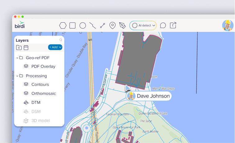
Site plans rarely arrive the way a map wants them: a drawing set as one multi-page PDF, a plan exported without coordinates, a scan of a paper drawing from the site office. Until now, only a single-page georeferenced PDF could go on your Birdi map. Everything else sat in the Layers panel as a document, next to your capture but never over it.
Not anymore. You can now pick the sheets you need from a drawing set, and line up a page or image that has no coordinates by matching a few points to the map. Your drawing sits over your latest orthomosaic, so you can see whether what was built is where the design says it should be.
(Available on Plus, Growth and Ultimate plans)
What's new
- Multi-page PDFs: pick the pages you want, and each one becomes its own layer in a Geo-ref PDF folder. Pages with coordinates go straight onto the map, even when the same PDF mixes both kinds
- Drawings without coordinates: choose Add as map overlay, then click a feature on the drawing and the same spot on the map, or type its latitude and longitude. A live preview shows the fit as you go
- Scanned plans and images: scans, photographed paper plans, and JPG and TIFF files can go on the map too
- CAD drawings stay sharp: a PDF with vector data, such as a CAD export, comes in as a vector layer in its original colors. Hide individual CAD layers and use all of Birdi's vector styling
- Pick up where you left off: a file you haven't finished shows a choose pages or needs alignment tag in the Layers panel. Click it to carry on
What you'll need
- A Plus, Growth or Ultimate plan
- A PDF, JPG or TIFF of your drawing
Line it up with a few points
Click a corner on the drawing, then the same corner on your map. Two points place the drawing. Three make it more accurate. Four or more show how far off each point is, so you know the fit is right before you save.
Then fade the drawing over your latest orthomosaic and see the design and the site together.
Where it helps most
- Checking work against the design: put the setout plan over this week's capture and look for what's out of place. Our guide to checking as-built work walks through it
- Consultant drawings, in one view: share the drawings with your team in the same map as your capture data
- Old paper plans: bring a scanned historical plan into the same view as today's site
Getting set up
- Upload your file as usual: click +Add data, then Upload files.
- For a multi-page or georeferenced PDF, click Next: choose pages and tick the pages you want.
- For a file without coordinates, right-click it in the Layers panel and choose Add as map overlay.
- Match your points on the drawing and the map, and watch the live preview.
- Click Save alignment. To fine-tune it later, right-click the drawing and choose Adjust alignment.
The full step-by-step walkthroughs are in our Knowledge Base: How to add a georeferenced PDF to your map as a layer and How to add a PDF or image without coordinates to your map
FAQ
Which plans include map overlays?
Plus, Growth and Ultimate.
Which files can I put on the map?
PDFs, including multi-page drawing sets and PDFs that mix pages with and without coordinates, plus JPG and TIFF images. A TIFF that already has coordinates goes straight onto the map, and CAD exports come in as sharp vector layers.
Can I use scans and photos of paper plans?
Yes. Scanned plans and photographed paper plans go on the map as images, alongside JPG and TIFF files. Match a few points to the map and they sit right over your latest capture.
Can I change the alignment later?
Yes. Right-click the drawing in the Layers panel and choose Adjust alignment. You can also add more pages from the same PDF at any time.
Your drawings, on your site
The design and the capture finally sit in one place. Upload your next site plan or drawing set to a Birdi map and see how the site measures up.
👉 Learn more in the Knowledge Base
Related reading: What is georeferencing and why does it matter for site surveys? · How to line up a site plan without coordinates on a drone map · What's new in Birdi: October 2026