
Measuring stockpile volumes with shared insight and AI detection

Measuring stockpile volumes is a routine task for many mining, quarrying, and materials teams — but the way it’s done can have a big impact on confidence, collaboration, and audit readiness.
Over the years, drone-based stockpile surveys have made volume measurement faster and safer. What’s changed more recently is how those results are reviewed and shared across teams. With Birdi’s newly launched stockpile AI detect, volume reporting becomes less about a single person producing a number, and more about creating a shared, reviewable source of truth.
.png)
What is stockpile volume measurement?
Stockpile volume measurement is the process of calculating the volume of material stored on site by comparing a stockpile surface against a reference surface. Using drone data and geospatial software, teams can measure stockpiles accurately, track changes over time, and support operational reporting, audits, and inventory reconciliation.
In this post, we’ll look at modern approaches to stockpile volume measurement, where AI-assisted detection fits in, and why shared insight matters — especially when volumes are used for audits, reconciliation, and decision-making.
Stockpile volume measurement: a quick refresher
At its core, stockpile volumetric reporting compares a stockpile surface against a reference surface (often the surrounding ground or a previous survey) to calculate volume. Traditionally, this involved:
- Manual surveys or GPS-based methods
- Time on site and safety exposure
- Manual delineation of stockpile boundaries in software
Drone mapping changed that by allowing teams to capture high-resolution aerial data and generate accurate surfaces. If you want a deeper walkthrough of the fundamentals, we’ve covered that in detail here: Measuring stockpile volumes made easy: A guide to volumetric reporting
What many teams still struggle with, though, is consistency and review — especially when multiple people are involved.
Where stockpile reporting usually breaks down
Even with good drone data, stockpile reporting can introduce friction:
- Different operators draw slightly different stockpile boundaries
- Assumptions aren’t always documented
- Results are shared as static numbers or PDFs, without context
- Auditors or managers can’t easily see how a volume was calculated
This is where trust can erode. When volumes feed into inventory reporting, financial reconciliation, or compliance audits, teams need more than just a final number — they need visibility.
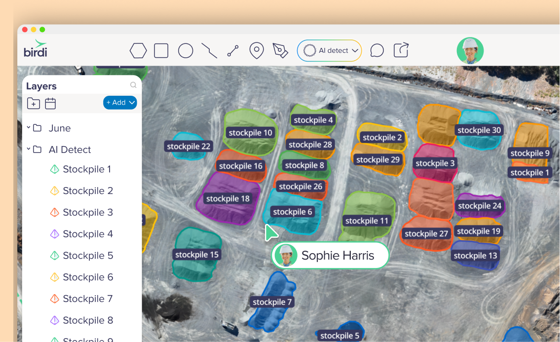
Introducing Stockpile AI Detect
Stockpile AI Detect is designed to remove some of the manual guesswork from volumetric reporting.
Instead of starting from scratch each time, AI Detect automatically identifies stockpile shapes from processed surface data. This gives teams:
- A consistent starting point for volume calculations
- Faster setup, especially on sites with many stockpiles
- Reduced variation between different operators
Importantly, AI Detect doesn’t remove human oversight. It creates a baseline that can be reviewed, adjusted, and approved, which is where collaboration really comes into play.
.png)
Turning volumes into shared insight
One of the biggest shifts we’re seeing is teams treating stockpile volumes as shared spatial data, not isolated outputs.
Within a collaborative geospatial platform like Birdi, stockpile volumes can be:
- Viewed directly on the map alongside the underlying surface
- Reviewed by multiple team members without exporting files
- Annotated to explain assumptions or changes
- Compared over time using consistent detection logic
This makes it much easier for operations, engineering, and management teams to align on the same numbers — and understand how they were produced.
Supporting audits and compliance
For audits, transparency matters.
Instead of relying on screenshots or spreadsheets, teams can provide:
- A visual record of detected stockpiles
- Clear boundaries used for each volume calculation
- Historical datasets showing changes over time
- Contextual notes directly on the map
This approach helps auditors and internal reviewers trace volumes back to the source data, reducing back-and-forth and increasing confidence in reported figures.
.png)
From individual workflows to team workflows
Stockpile reporting is rarely a solo task for long. As operations scale, volumes are reviewed by supervisors, planners, finance teams, and external stakeholders.
AI-assisted detection helps standardize the starting point, while shared map-based review ensures everyone is working from the same spatial understanding. Instead of asking, “Where did this number come from?”, teams can explore the answer visually.
A more connected approach to volumetrics
Measuring stockpile volumes will always require good data and sound methodology. What’s changing is the expectation around collaboration, traceability, and speed.
With stockpile AI detect and shared spatial review, volumetric reporting becomes:
- Faster to produce
- Easier to review
- More defensible for audits
- More useful across teams
If you’re already capturing drone data, the next step is making sure those insights don’t live in silos.