
How Blue Nose Aerial Imaging delivers drone mapping insights across 45+ U.S. franchises

.png)
Challenge
Blue Nose Aerial Imaging operates one of the largest drone services franchise networks in the United States, with more than 45 independently operated teams delivering aerial mapping, inspections and documentation across the country.
From Washington to Florida and New York to California, Blue Nose operators support a wide range of industries, with a particular focus on construction, where regular site monitoring and visual documentation are essential.
Drone mapping produces valuable project data, including aerial imagery, orthomosaics and 3D models. But delivering that information to clients in a way that is easy to understand can be challenging. Before Birdi, project data was delivered through traditional methods such as email attachments or shared cloud folders. While this allowed files to be transferred, it didn’t provide clients with a clear or interactive way to explore the data or understand what the results meant for their projects.
Blue Nose wanted a more professional way to present site insights — allowing clients to view and interact with maps, imagery and project information directly rather than navigating folders of static files.

Franchisee Adam Valdes – Blue Nose Aerial Imaging – Northern Virginia – Data Center Mapping
Solution
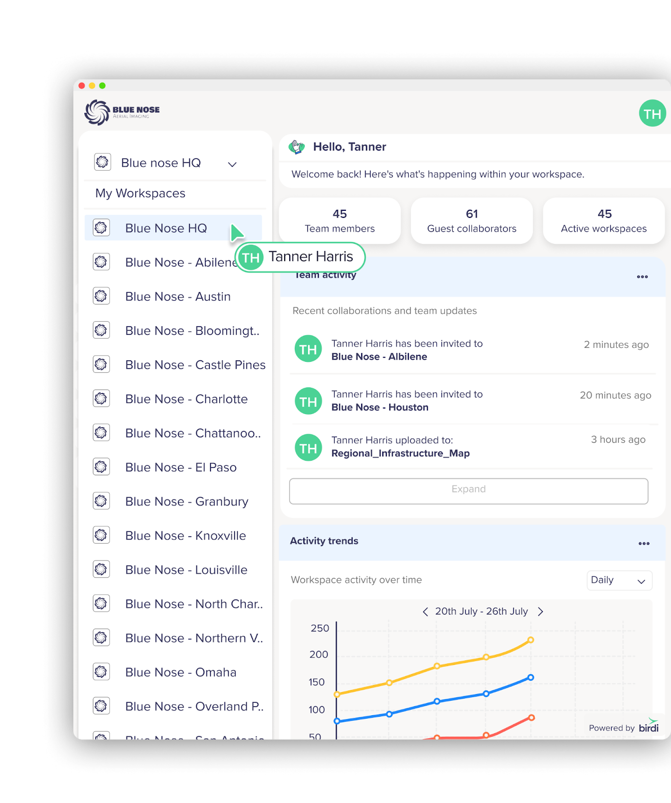
With Birdi, Blue Nose franchise operators can upload drone imagery, process mapping outputs and deliver project data through a shared geospatial platform. Each franchisee manages their own organization within Birdi, with dedicated workspaces for each client — making it easy to keep projects organized while providing clients with their own branded environment to view maps and insights.
Birdi has also become an important part of how Blue Nose franchise owners present their services to prospective clients. By demonstrating the platform, operators can show the type of maps, insights and interactive project views clients will receive. This helps Blue Nose teams clearly communicate the value of their drone services and differentiate themselves when competing for new work.
The platform allows Blue Nose operators to bring together orthomosaics, 3D models, point clouds and other geospatial datasets into a single workspace. By visualizing site data in one place and sharing interactive maps directly with clients via a simple link, operators can communicate project insights more clearly while delivering a consistent experience across the Blue Nose franchise network.
Blue Nose teams use Birdi to:
- Process drone imagery into mapping outputs such as orthomosaics, point clouds and 3D models
- Visualize project data in both 2D and 3D to better understand site conditions
- Overlay engineering plans and geospatial datasets for additional project context
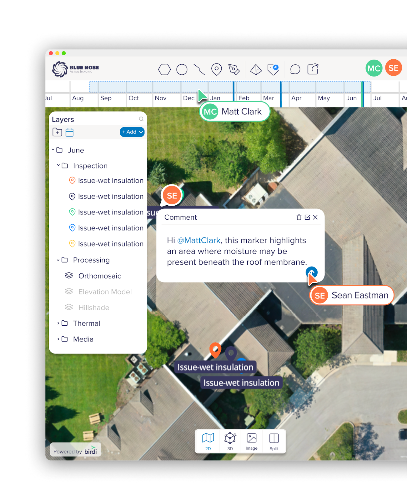
- Annotate imagery and maps to highlight site observations and inspection findings
- Share interactive project maps with clients through secure, client-branded workspaces
Drone imagery processing and mapping outputs
Blue Nose franchise operators regularly capture aerial imagery of construction sites to enable project monitoring and documentation for their clients.
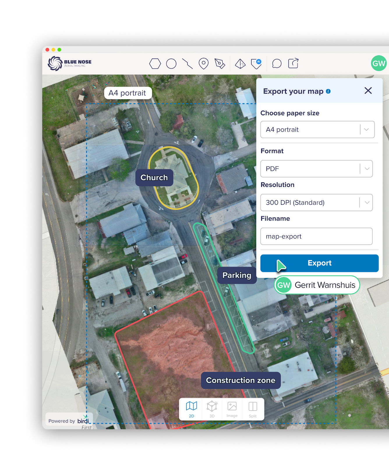
Once uploaded into Birdi, this imagery is processed into mapping outputs such as orthomosaics, point clouds and 3D models. These outputs provide detailed visual representations of project sites that allow teams to track progress and better understand site conditions over time.
Accurate coordinate systems and elevation data help ensure that the outputs produced can be used confidently for analysis, reporting and communication with project stakeholders.
Geospatial data visualization and shared insights
Birdi provides Blue Nose teams with a collaborative workspace where multiple types of geospatial data can be viewed together.
Mapping outputs can be layered with industry-standard formats such as shapefiles, KML, GeoJSON and DXF. This allows operators to overlay engineering plans, survey information and captured imagery within the same workspace.
By bringing these datasets together visually, Blue Nose’s clients can quickly interpret site conditions and communicate insights.
Visual inspections and reporting

Franchisee James Snelson – Blue Nose Aerial Imaging – Abilene – Stockpile reporting
Operators across the Blue Nose network use map-based annotations and image markups to highlight issues and document observations from site inspections for their clients.
Rather than relying on lengthy reports or scattered photos, teams can mark areas directly on imagery and maps. This allows their construction team and asset owner clients to quickly understand site conditions and identify areas that may require attention, without needing specialized geospatial tools.
This approach helps streamline inspection reporting and reduces the time spent explaining complex datasets.
Collaborative client deliverables
Instead of delivering mapping outputs through email attachments or file-sharing services, Blue Nose teams can share projects with clients through simple map links. Clients can explore maps, imagery and outputs directly within the platform, giving them a clearer understanding of project conditions and progress.
This shared view of site data reduces back-and-forth communication and helps ensure everyone involved in the project is working from the same source of truth.
AI-assisted site analysis
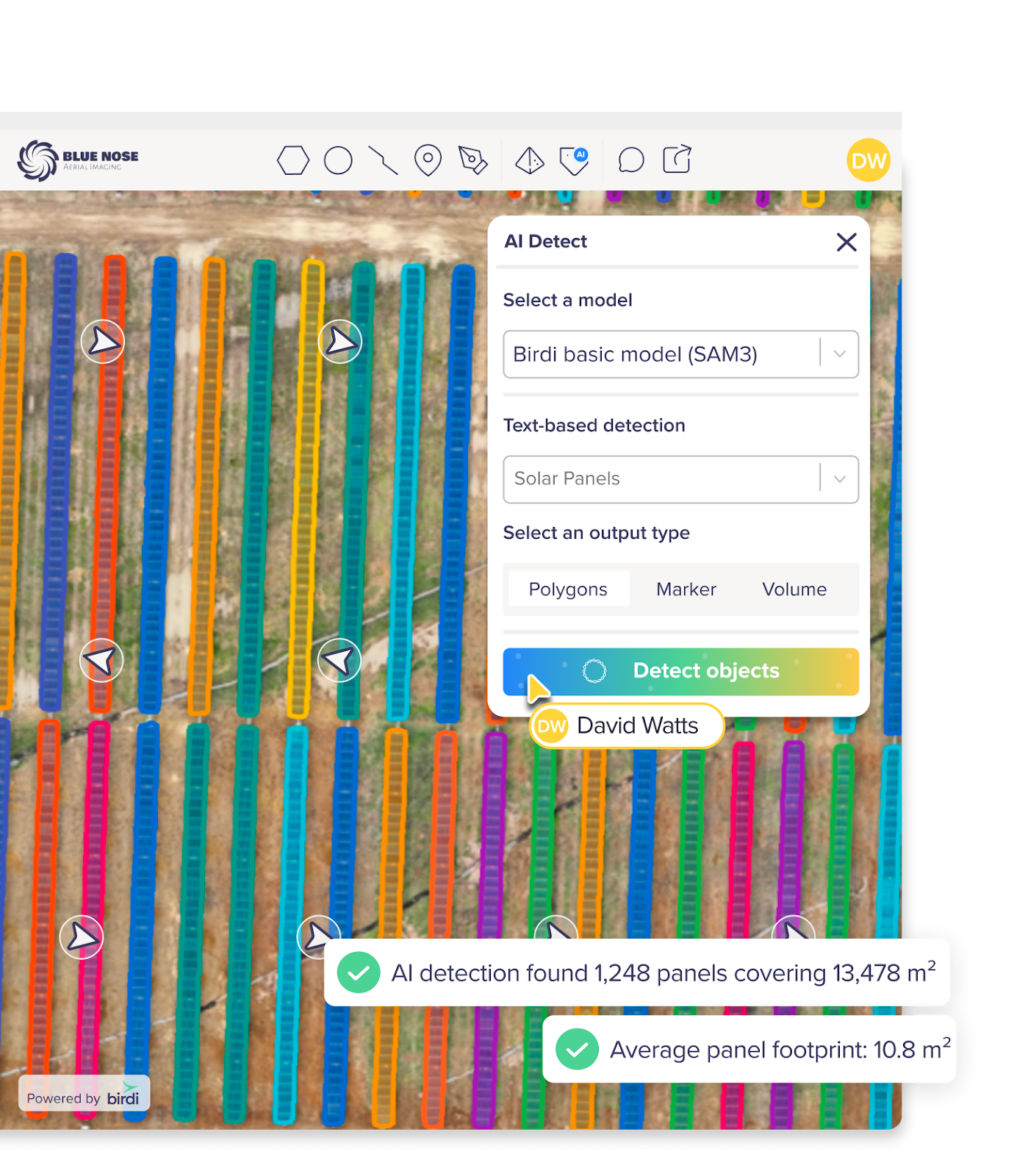
Some Blue Nose operators have also begun experimenting with AI-powered detection tools to help identify features within captured imagery. These tools help teams analyze site imagery more efficiently while providing valuable feedback that helps improve detection accuracy over time.
Results and benefits of using Birdi
- More professional client deliverables: Blue Nose teams can provide clients with interactive project maps instead of sending files or folders, improving how results are presented and understood.
- Clearer site insights: Combining drone imagery, mapping outputs and project data in one workspace makes it easier for clients to interpret site conditions and communicate findings.
- Improved collaboration with clients: Shared access to project maps allows clients and stakeholders to explore results directly and stay aligned on project progress.
- Scalable operations: With more than 30 franchises operating across the United States, Birdi provides a platform that supports consistent project delivery as the Blue Nose network continues to grow.
By giving franchise operators a clear way to process, visualize and share geospatial data, Birdi helps Blue Nose deliver a more professional and collaborative experience for their clients. Construction teams can access project insights directly, while Blue Nose operators can focus on capturing and communicating the information that helps projects move forward.